Journey of Weather Buoys at Seas
8 December 2022
CK Chow and Queenie CC Lam
The ocean covers about 70% of the Earth’s surface and affects Earth’s weather and climate. However, weather observations over the ocean are much less than those on the land. As such, the addition of oceanographic and meteorological observation equipment in data sparse sea areas can assist in monitoring weather and the development of tropical cyclones, further enhancing the capability in forecasting tropical cyclone intensity, and thus contributing to navigation safety in the region.
Drifting buoy is a commonly deployed device for ocean observations. It consists of meteorological sensors like atmospheric pressure sensor (barometer) and temperature sensor (thermistor), a battery power source, and a satellite transmitter that relays the data through satellite system (Figure 1). It can also be used to track ocean currents (typically at a depth of 15 metres) beneath the ocean surface. The lifetime of a drifting buoy could be as long as a year or so, but in general it only lasts for a few months on average due to vandalism, running aground, battery problem and etc.
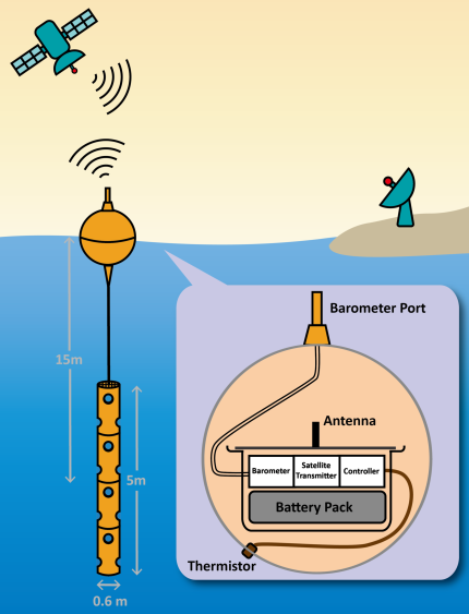
Figure 1. A schematic diagram showing the major components and operation of a drifting buoy.
In June 2015, the Hong Kong Observatory (HKO) collaborated with the Hong Kong Voluntary Observing Ship (HKVOS) to deploy the first drifting buoy in the South China Sea to make meteorological and oceanographic observations. The deployment continues since then. The buoy drifts following the ocean currents and makes in-situ measurements of sea level pressure and sea surface temperature. The data are transmitted to the Observatory every hour via the Iridium satellite and disseminated over the GTS. Figure 2 shows the deployment of a drifting buoy over the northern part of the South China Sea with the help of a HKVOS.
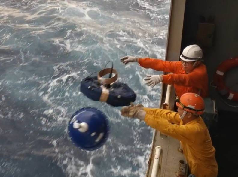
Figure 2. Drifting buoy deployed by the crews of a HKVOS (Photo courtesy of Orient Overseas Container Line (OOCL))
In 2021, the HKO deployed three drifting buoys in the South China Sea and two in the western North Pacific (Figure 3). These buoys drifted across a wide area of the seas (Figure 3). Buoy codenamed “AMOHK29” even broke the HKO’s longest buoy record operating more than one year during its lifetime, wandering from seas east of Luzon to near the International Date Line. Interestingly, it followed the Kuroshio Current (also known as the Black Current) south of Japan and fully manifested the meandering characteristics of the Current.
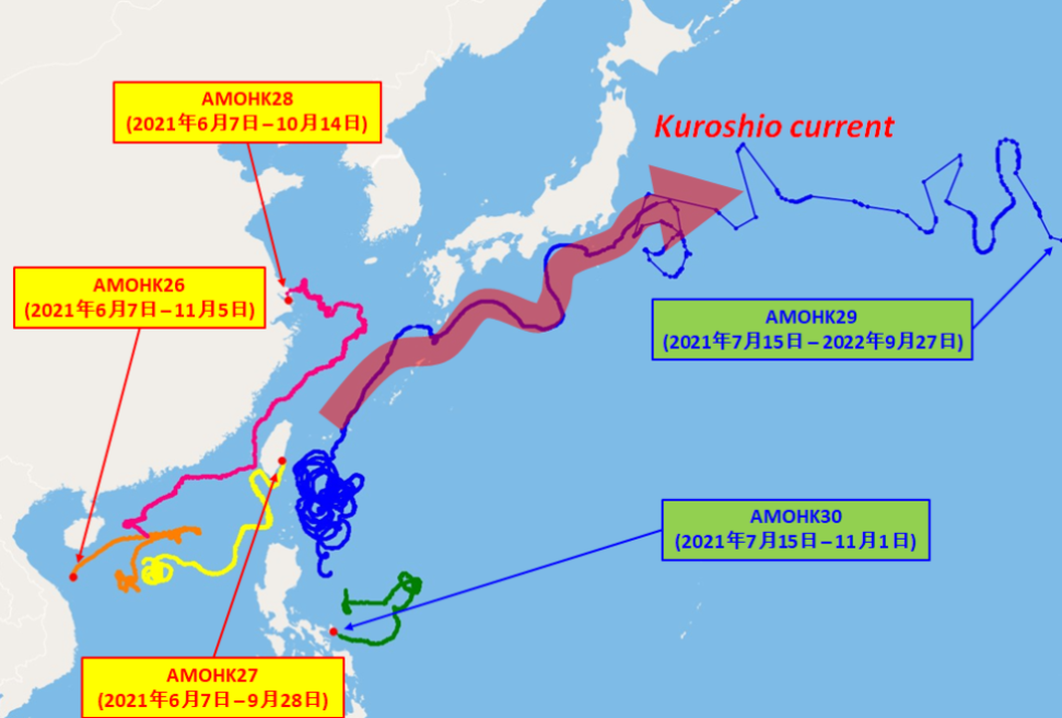
Figure 3. Tracks of five drifting buoys deployed by HKO over the South China Sea and the western North Pacific in 2021. The codename of the buoys and their operating period are given inside the boxes while the red dots denote their last reported position.
The buoys encountered several tropical cyclones during their drifting journey. Real-time observations of sea level pressure and sea surface temperature during their lifetime are useful for monitoring the development of tropical cyclones and estimating their intensity, especially when they have close encounter such as on 13 October 2021 when a surface pressure of around 978.6 hPa was recorded near the centre of tropical cyclone Kompasu (Figure 4). The lower the pressure, the stronger the cyclone (Figure 5).
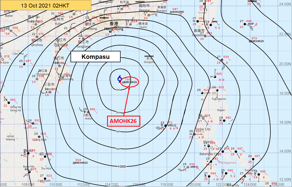
Figure 4. Close encounter of buoy “AMOHK26” with tropical cyclone Kompasu over the South China Sea at 02 HKT on 13 October 2021.
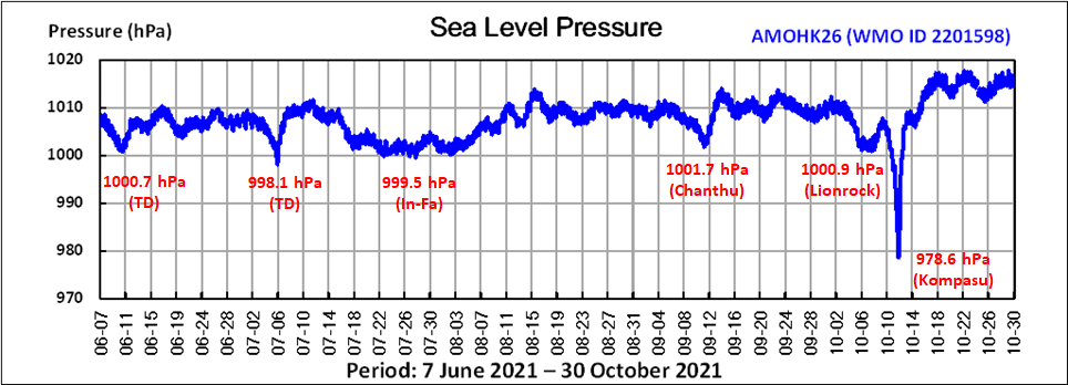
Figure 5. Time series of sea level pressure measured by buoy “AMOHK26” capturing the low pressures associated with a number of tropical cyclones over the South China Sea in 2021.
In 2022, two drifting buoys were deployed in the South China Sea in early July (Figure 6). They collected useful observations during the passage of tropical cyclones Mulan, Ma-on and Noru which traversed the South China Sea in August and September 2022. Both drifting buoys were within the circulation of the cyclones and captured the associated low pressures (Figures 7 and 8).
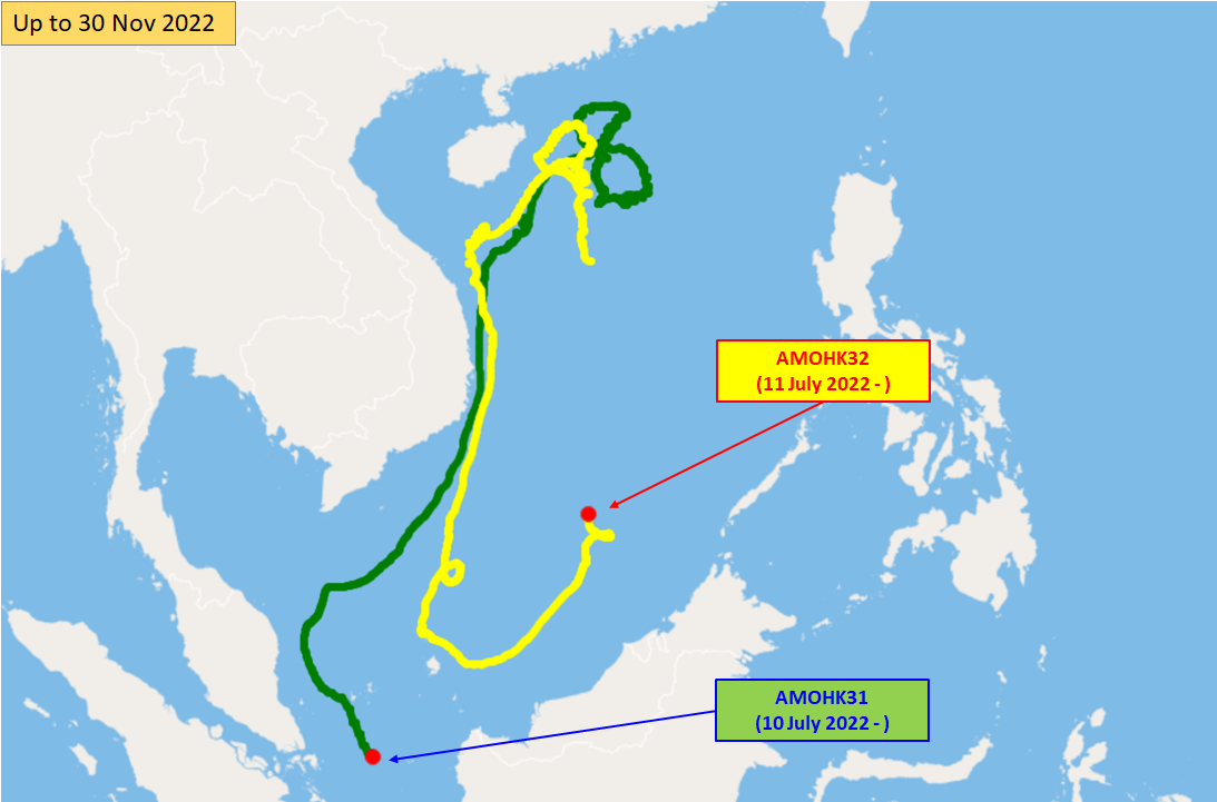
Figure 6. Similar to Figure 3 but for two drifting buoys deployed in 2022.
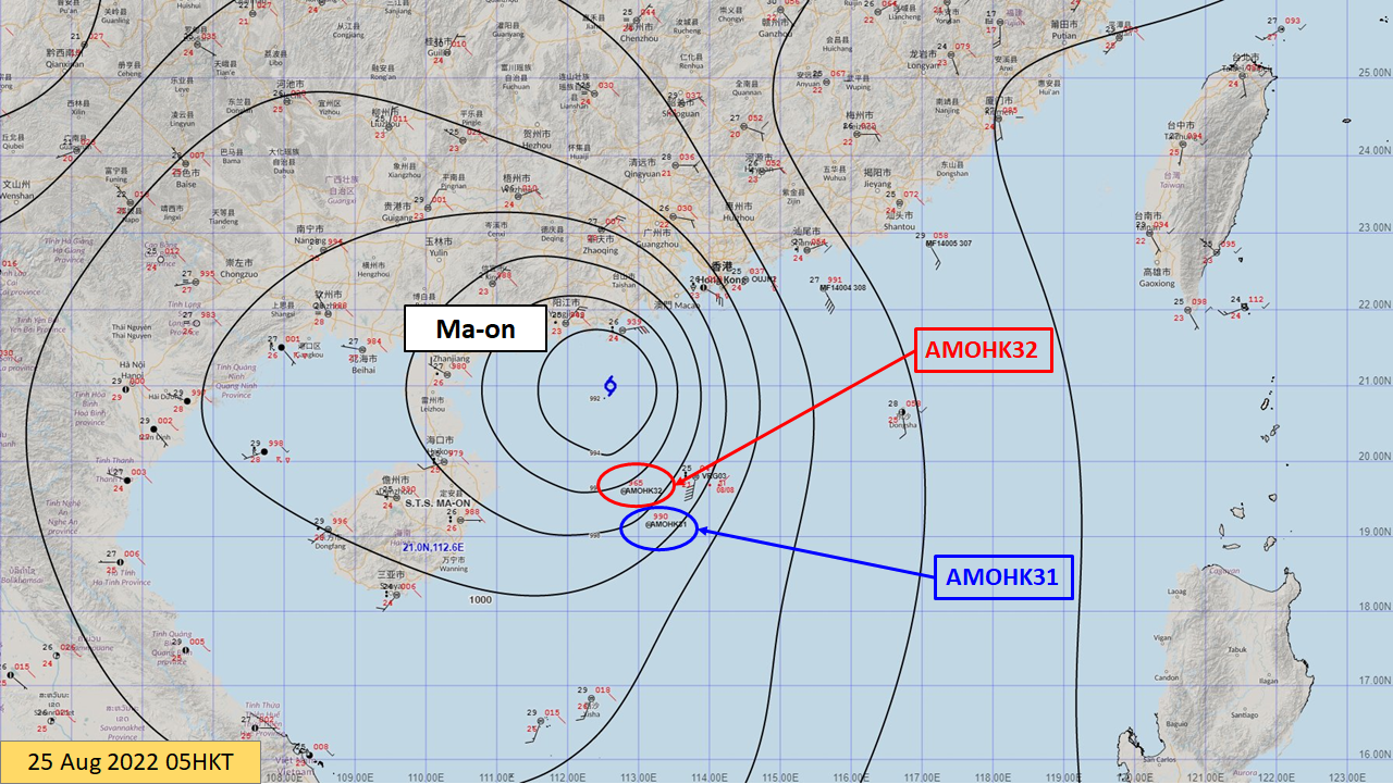
Figure 7. Both buoys “AMOHK31” and “AMOHK32” over the northern part of the South China Sea were within the circulation of tropical cyclone Ma-on at 05 HKT on 25 August 2022.
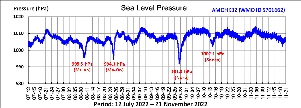
Figure 8. Similar to Figure 5 but for buoy “AMOHK32”, recording the lowest pressures associated with tropical cyclones on its encounter over the northern part of the South China Sea.
Internationally, the HKO has been participating in the Barometer Upgrade Program of the Data Buoy Cooperation Panel (DBCP), an international program under the World Meteorological Organization (WMO) and the Intergovernmental Oceanographic Commission (IOC) of the United Nations Educational, Scientific and Cultural Organization (UNESCO). The DBCP maintains a network of thousands of drifting buoys operated by national weather services around the world and coordinates the use of buoy data to observe atmospheric and oceanographic conditions. Figure 9 shows the distribution of drifting buoys providing barometric pressure measurements in August 2021.
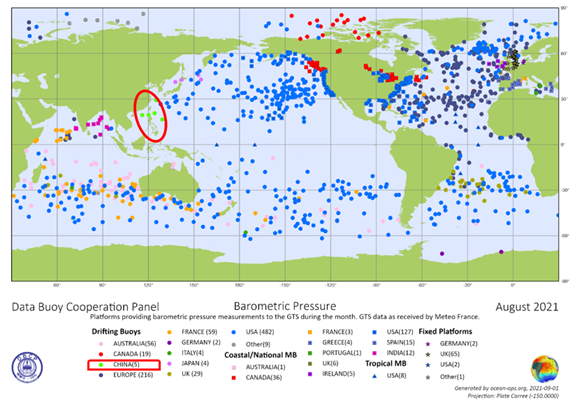
Figure 9. Distribution of drifting buoys providing barometric pressure measurement in August 2021. Green dots in the red circle show the drifting buoys deployed by the HKO. (Data source from OceanOPS website)
In the future, the HKO will continue deploying drifting buoys over the South China Sea and the western North Pacific with optimised strategy in order to increase the chance of monitoring tropical cyclones along their journey during the tropical cyclone season.