How to interpret the tropical cyclone forecast track map?
22 June 2015
The Hong Kong Observatory (HKO) has recently extended its tropical cyclone track forecast from 3 days to 5 days. What kind of useful information can we draw from the enhanced forecast track map?
In fact, the benefits brought by the extended forecast tracks are pretty obvious. For example, in early May this year (2015), when Tropical Cyclone Noul developed over the western North Pacific and moved west towards Luzon, people started to pay attention to it and discussed whether it would directly affect Hong Kong. The 3-day forecast track issued by HKO on the morning of 7 May indicated that Noul would move westward steadily, with the tendency to enter the South China Sea (Figure 1). On the other hand, the then 5-day forecast track still under testing at HKO suggested that Noul would recurve and track towards Taiwan in the next 4 to 5 days (11 and 12 May), leaving little direct threat to the weather of Hong Kong. Actually, Noul started to recurve before reaching Luzon and then skirted across the seas east of Taiwan (Figure 2). This demonstrates that an extension of the range of forecast track could help people know earlier about the future possible movement of the tropical cyclones and respond accordingly. In the case of Noul, people staying in Hong Kong should not too worry about the situation, but people planning to go to Taiwan should make timely preparations.
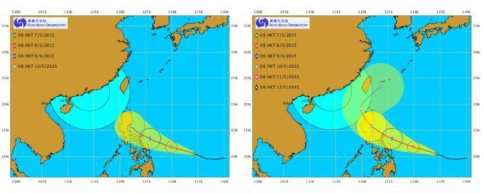
Figure 1The 3-day and 5-day forecast tracks of Tropical Cyclone Noul
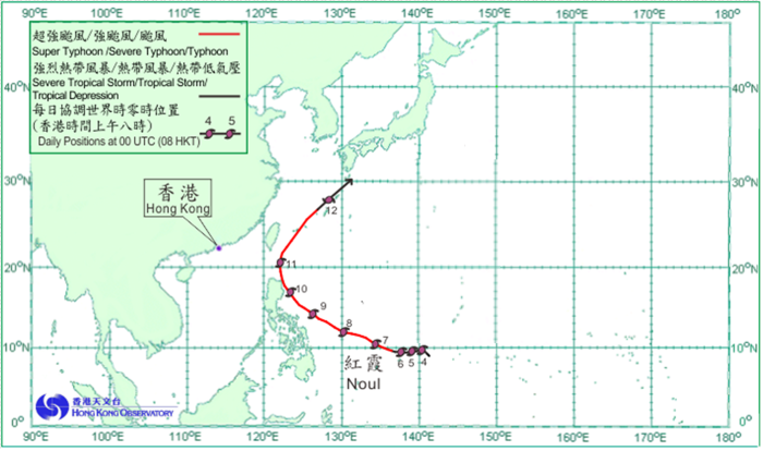
Figure 2Actual track of Noul
Are the extended forecast tracks reliable?
The ability of HKO issuing longer forecast tracks can be attributed to the considerable improvement in the track forecast accuracy achieved in recent years. According to the results of objective verification, the accuracy of the fifth-day forecast position of the tropical cyclones is now comparable to that of the third-day forecast first introduced in 2003. In fact, the position error for the 24 hour forecasts was still close to 200 km in the year of 2000 and before. Yet, this error has persistently fallen below 100 km from 2010 onwards. The skill of the track forecasts issued by HKO is indeed on par with that of the major forecast agencies in the region [1]-[3].
How about the yellow shaded area covering the forecast track?
Weather changes invariably. Just like other weather forecasts, errors are always inherent at some level in the tropical cyclone forecast tracks and perfect forecast could hardly be achieved. In general, the accuracy of the track forecasts declines (viz. the growth of the forecast error) as the forecast range increases. In other words, the confidence of forecasters in the forecast position for day 5 should be less than that for day 1. To help people appreciate the forecast uncertainties in the track forecasts, the Observatory has introduced the "Potential Track Area" (the yellow shaded area in Figure 1) to indicate the area within which the tropical cyclone will possibly be located. The "Potential Track Area" is constructed by joining five different circles centred at the 24, 48, 72, 96 and 120-hour forecast positions respectively. The sizes of the circles are defined from the error statistics in the past years such that the tropical cyclone is expected to fall within the respective circle at each forecast hour with a probability of about 70%. This means that in 10 times of similar track forecast, about seven times the tropical cyclone centre will be located within the indicated area. The presentation of track forecast uncertainties in the form of probability has now been widely adopted by the forecast agencies around the world.
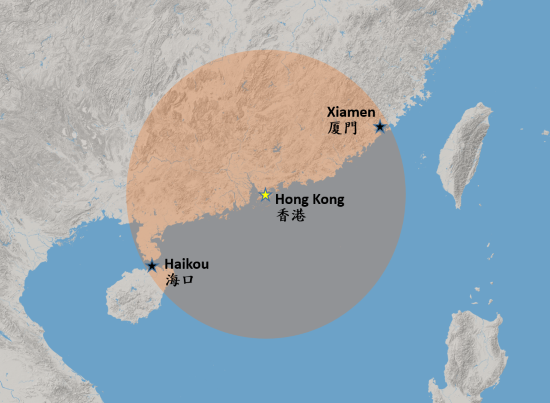
Figure 3The area within 500 km from Hong Kong
The "Potential Track Area" essentially reflects the current level of skills in tropical cyclone track forecasting. At present, the radius of the circle which corresponds to the fifth-day forecast amounts to 500 km. People should fully understand and take into account the inherent uncertainties when using the track forecasts. For example, if the Observatory predicts that a tropical cyclone will make landfall over Hong Kong five days from now, the tropical cyclone could still possibly end up making landfall over as far west as the City of Haikou on the Hainan Island, or over the City of Xiamen in the Fujian Province in the east. Furthermore, there exists some 30% chance that the tropical cyclone will be passing at a farther distance away from Hong Kong.
Information not provided by the forecast track map
While a tropical cyclone only appears as a symbol on the forecast track map, the associated inclement weather such as strong winds, heavy rain, rough seas, swells, or storm surge will definitely affect beyond a single point and reach as far as hundreds of kilometres away from the storm centre, and may even be reaching well beyond the "Potential Track Area". In addition to the movement track, the extent of area that will be impacted by the tropical cyclone also depends on other factors such as the size of the circulation, intensity, structure and propagation speed of the storm. Due to the same reason, it is not easy at all to deduce the local weather solely from the forecast track. People should constantly pay attention to the latest warnings or reports about the tropical cyclone issued by the Observatory.
Chan Sai-tick
References
[1] Activities of the RSMC Tokyo - Typhoon Center in 2014
https://www.typhooncommittee.org/3rdJS/Docs/2.%20Review%20tc2014/2.4%20ReviewRSMCActivities_2014.pdf.
[2] Member Report of China (2014)
https://www.typhooncommittee.org/9IWS/DOCS/Members%20Report/China/member_report_china_20141018.pdf.
[3] Annual Tropical Cyclone Report 2013, Joint Typhoon Warning Center
https://www.usno.navy.mil/NOOC/nmfc-ph/RSS/jtwc/atcr/2013atcr.pdf.
In fact, the benefits brought by the extended forecast tracks are pretty obvious. For example, in early May this year (2015), when Tropical Cyclone Noul developed over the western North Pacific and moved west towards Luzon, people started to pay attention to it and discussed whether it would directly affect Hong Kong. The 3-day forecast track issued by HKO on the morning of 7 May indicated that Noul would move westward steadily, with the tendency to enter the South China Sea (Figure 1). On the other hand, the then 5-day forecast track still under testing at HKO suggested that Noul would recurve and track towards Taiwan in the next 4 to 5 days (11 and 12 May), leaving little direct threat to the weather of Hong Kong. Actually, Noul started to recurve before reaching Luzon and then skirted across the seas east of Taiwan (Figure 2). This demonstrates that an extension of the range of forecast track could help people know earlier about the future possible movement of the tropical cyclones and respond accordingly. In the case of Noul, people staying in Hong Kong should not too worry about the situation, but people planning to go to Taiwan should make timely preparations.
Figure 1The 3-day and 5-day forecast tracks of Tropical Cyclone Noul
Figure 2Actual track of Noul
Are the extended forecast tracks reliable?
The ability of HKO issuing longer forecast tracks can be attributed to the considerable improvement in the track forecast accuracy achieved in recent years. According to the results of objective verification, the accuracy of the fifth-day forecast position of the tropical cyclones is now comparable to that of the third-day forecast first introduced in 2003. In fact, the position error for the 24 hour forecasts was still close to 200 km in the year of 2000 and before. Yet, this error has persistently fallen below 100 km from 2010 onwards. The skill of the track forecasts issued by HKO is indeed on par with that of the major forecast agencies in the region [1]-[3].
How about the yellow shaded area covering the forecast track?
Weather changes invariably. Just like other weather forecasts, errors are always inherent at some level in the tropical cyclone forecast tracks and perfect forecast could hardly be achieved. In general, the accuracy of the track forecasts declines (viz. the growth of the forecast error) as the forecast range increases. In other words, the confidence of forecasters in the forecast position for day 5 should be less than that for day 1. To help people appreciate the forecast uncertainties in the track forecasts, the Observatory has introduced the "Potential Track Area" (the yellow shaded area in Figure 1) to indicate the area within which the tropical cyclone will possibly be located. The "Potential Track Area" is constructed by joining five different circles centred at the 24, 48, 72, 96 and 120-hour forecast positions respectively. The sizes of the circles are defined from the error statistics in the past years such that the tropical cyclone is expected to fall within the respective circle at each forecast hour with a probability of about 70%. This means that in 10 times of similar track forecast, about seven times the tropical cyclone centre will be located within the indicated area. The presentation of track forecast uncertainties in the form of probability has now been widely adopted by the forecast agencies around the world.
Figure 3The area within 500 km from Hong Kong
The "Potential Track Area" essentially reflects the current level of skills in tropical cyclone track forecasting. At present, the radius of the circle which corresponds to the fifth-day forecast amounts to 500 km. People should fully understand and take into account the inherent uncertainties when using the track forecasts. For example, if the Observatory predicts that a tropical cyclone will make landfall over Hong Kong five days from now, the tropical cyclone could still possibly end up making landfall over as far west as the City of Haikou on the Hainan Island, or over the City of Xiamen in the Fujian Province in the east. Furthermore, there exists some 30% chance that the tropical cyclone will be passing at a farther distance away from Hong Kong.
Information not provided by the forecast track map
While a tropical cyclone only appears as a symbol on the forecast track map, the associated inclement weather such as strong winds, heavy rain, rough seas, swells, or storm surge will definitely affect beyond a single point and reach as far as hundreds of kilometres away from the storm centre, and may even be reaching well beyond the "Potential Track Area". In addition to the movement track, the extent of area that will be impacted by the tropical cyclone also depends on other factors such as the size of the circulation, intensity, structure and propagation speed of the storm. Due to the same reason, it is not easy at all to deduce the local weather solely from the forecast track. People should constantly pay attention to the latest warnings or reports about the tropical cyclone issued by the Observatory.
Chan Sai-tick
References
[1] Activities of the RSMC Tokyo - Typhoon Center in 2014
https://www.typhooncommittee.org/3rdJS/Docs/2.%20Review%20tc2014/2.4%20ReviewRSMCActivities_2014.pdf.
[2] Member Report of China (2014)
https://www.typhooncommittee.org/9IWS/DOCS/Members%20Report/China/member_report_china_20141018.pdf.
[3] Annual Tropical Cyclone Report 2013, Joint Typhoon Warning Center
https://www.usno.navy.mil/NOOC/nmfc-ph/RSS/jtwc/atcr/2013atcr.pdf.