The "Geng-Zi" typhoon disaster in 1900
9 May 2013
While about 90 percent of the tropical cyclones affecting Hong Kong occur between June and October, tropical cyclone warnings have been issued in November or even into early December due to the approach of some late-season "autumnal typhoons". Typhoons approaching the South China coast late in the year are often weakened by the northeast monsoon. However, in the early hours of 10 November 1900, Hong Kong was caught off guard by the fierce winds of a typhoon. Since the year 1900 was the "Geng-Zi" year in the Chinese calendar, this late-autumn typhoon event was called the "Geng-Zi typhoon disaster ( 庚子風災 )". Despite being one of the deadliest in Hong Kong history, this typhoon event is less known to many people when compared with the other major pre-World War II typhoon disasters in 1874, 1906, and 1937. Therefore, we have collated information from a number of government reports, newspapers and historical meteorological records published around that time to unveil further details about this autumnal typhoon disaster[1-6].
The ignored typhoon signals
The typhoon originated over the sea to the east of the Philippines on 5 November 1900. It tracked northwestward in the next couple of days and entered the South China Sea on 7 November. It then gradually turned northward edging towards the coast of Guangdong during 8 and 9 November (Figure 1). Based on the weather map at the time and the modern re-analysis, this typhoon appeared to be relatively large in size with a circulation of around 800 to 1000 kilometres in diameter (Figures 2 and 3). As such, both the Manila Observatory and Hong Kong Observatory had given due warnings to the public of the existence of this typhoon over the South China Sea. In Hong Kong, typhoon signals were hoisted starting from 8 November to warn the public of an approaching typhoon[5] . By 6:15 p.m. on 9 November, typhoon gun was fired to warn the public that gale force winds were expected in Hong Kong.
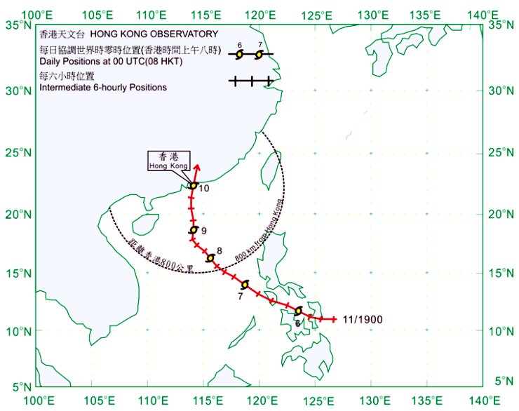
Figure 1Track of the centre of the "Geng-Zi" Typhoon from 5 to 10 November 1900.
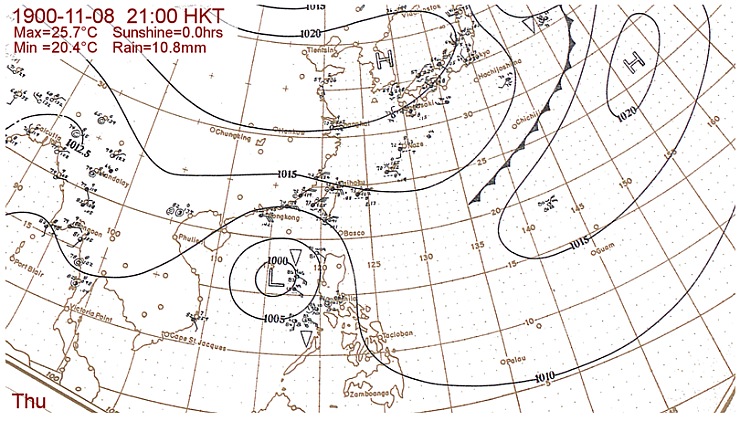
Figure 2Synoptic weather map on 8 November 1900.
(Data source: National Oceanographic Data Center of the US National Oceanic and Atmospheric Administration (NOAA) Central Library).
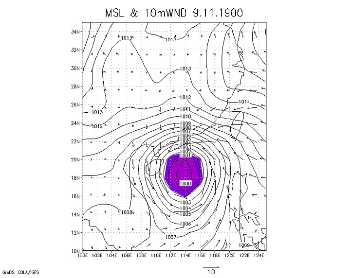
Figure 3Re-analysis of mean sea level pressure and 10-min Wind on 9 November 1900.
(Source : NOAA 20th Century "Reanalysis"[7] ).
With the typhoon approaching, the northeasterly winds in Hong Kong strengthened and reached gale force on the night of 9 November 1900. By 4 a.m. on 10 November, winds reached storm force at the Observatory as the eyewall of the typhoon approached from the south. By 5:00 a.m., the typhoon was at its height in the territory when the hourly mean wind speed at the Observatory reached about 61 knots (113 km/hr) (Figure 4). The center of the typhoon very likely passed over the eastern part of Hong Kong in the following 3 hours as the barometer at the Observatory fell to a minimum of 974.9 hPa at around 6:00 a.m. (Figure 5). This still stands as the lowest sea-level pressure record for November to date[9].
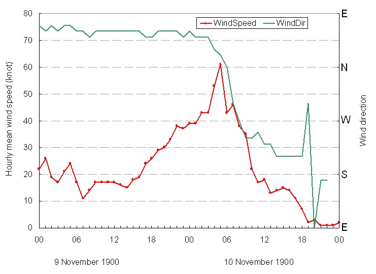
Figure 4Hourly mean wind speed and direction at the Hong Kong Observatory Headquarters (HKO Hq) on 9-10
November 1900. The wind speeds were calculated from data recorded by the Beckley anemometer at
HKO Hq in 1900 and the conversion factors from HKO Technical Note No. 66[8].
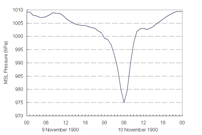
Figure 5Hourly mean sea level pressure recorded at HKO Hq from 9 to 10 November 1900.
Given the hourly observations taken at the Observatory through the typhoon event, we have made an attempt to estimate the possible hourly positions as well as the pressure pattern of the typhoon during its passage over Hong Kong. The results are depicted via an animation given here (http://www.hko.gov.hk/img/1900typ_obs_isobar_track.GIF). Note that the isobars shown in the animation were constructed based on the assumptions that the typhoon remained generally circular in shape and its intensity unchanged prior to landfall.
As per the reports from the Governor and newspapers[1, 4], the Observatory had given due notice of this impending typhoon to the public and the inclement weather also fully validated the Observatory's prediction. Regrettably, the public gave less attention to the warnings and little precautions were taken as many of them disbelieved that such a violent storm would affect the territory in this season.
How rare is this November typhoon?
As mentioned earlier, the maximum mean hourly wind speed at the Observatory reached 61 knots at 5 a.m. on 10 November. This value is comparable to the records of some of the well-known Signal No. 10 typhoons, such as Gloria (1957), Ruby (1964) and Rose (1971)[10]. In the 130-year record of the Observatory, this Geng-Zi typhoon was the first on record that had made landfall in Hong Kong in the month of November. The second tropical cyclone that had ever made landfall in Hong Kong in November occurred in 1939. This typhoon moved in a rare west to east direction across Hong Kong on 23 November 1939[11]. Signal No. 9 was hoisted during the height of the storm. Although the Hurricane Signal No. 10 did not exist in 1900, and had never been hoisted in November since its inception in 1931, the wind and pressure records at the Observatory strongly suggested that the Geng-Zi typhoon could have brought hurricane force winds in Hong Kong, especially over the eastern part.
Besides the 1900 and 1939 typhoons, there was only one more typhoon (1915) that had brought gale force winds at the Observatory during November before World War II. After World War II, there were two typhoons which necessitated the hoisting of Signal No. 8 or higher in November, namely the typhoons in 1954 (Signal No. 9) and 1972 (Signal No. 8). Coincidently, both of them were named Pamela. Counting all of the above-mentioned typhoons, Signal No. 8 or higher event in November occurred on an average of about every 26 years in the past 130 years in Hong Kong. Thus, statistically speaking, Hong Kong may be already due for the arrival of a late-autumn Signal No. 8 typhoon. The last time that tropical cyclone signal No. 3 or above were hoisted in the month of November due to a typhoon was already back in 1993 during the approach of Typhoon Ira. Although only Signal No. 3 was hoisted for Ira, a brief period of gale force winds was experienced in parts of the territory.
Damages and casualties
The "Geng-Zi" Typhoon caused extensive damages and heavy casualties to the territory (Figure 6). Numerous sampans and boats were sunk or even smashed to matchwood by the raging waves. Ten steam-launches and over 110 junks were also sunk and the harbour was full of wreckage. The gunboat H.M.S Sandpiper sank at her mooring and her crews, with one exception, were gallantly rescued by the torpedo-destroyer H.S.M. Otter. The large dredger "Canton River" was blown over and sunk. The Star Ferry pier was also heavily damaged. Over land, there were many reports of damages to houses, especially in the Peak District. All matsheds erected on the reclamation land over Yaumati were leveled to ground by the high winds. Many trees were damaged or uprooted. Lamp posts and telephone posts were bent at all angles by the furious winds. Over 200 lives were lost in these few fatal hours.
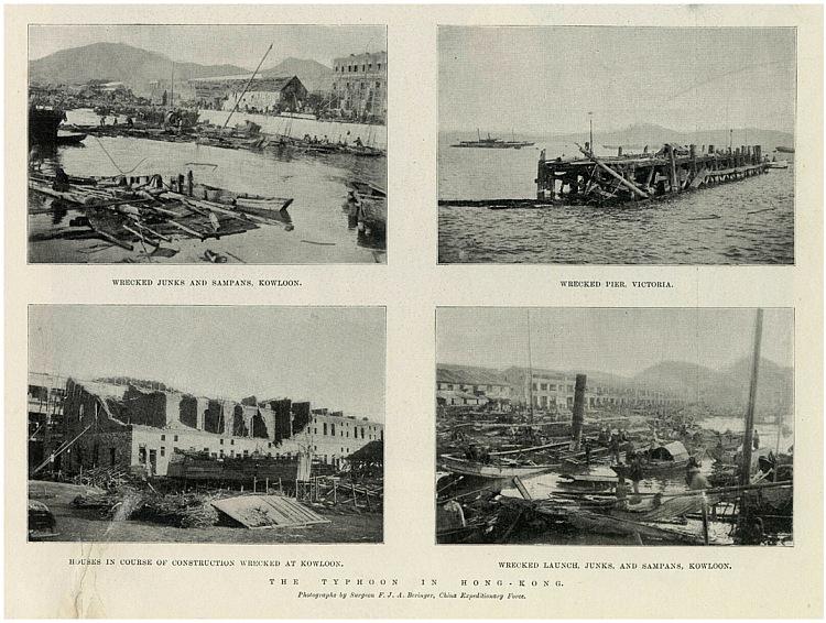
Figure 6Damages in Hong Kong brought by the "Geng-Zi" Typhoon as reported by the Illustrated London News on 22 December 1900.
Judging from the meteorological records and the historical document descriptions, this typhoon brought fearful havoc and desolation to the ill-prepared society in Hong Kong in 1900. This event highlights that, besides timely and accurate forecasts, the awareness and preparedness of the public to respond are also key factors of an effective typhoon warning system. No matter in peak or off-peak seasons, we should always remain vigilant to the typhoon threat in Hong Kong.
C.M. Shun(1), K.Y. Kong(2), and T.C. Lee(1)
(1) Hong Kong Observatory
(2) Weather Prediction Center - NOAA, U.S.A.
References:
[1] The China Mail, 10 November 1900
[2] The China Mail, 12 November 1900
[3] The Hong Kong Daily Press, 12 November 1900
[4] The Hong Kong Blue Book for the Year 1900
[5] Extract of Meteorological Observations, November 1900
[6] Meteorological Results 1900, Hong Kong Observatory
[7] NOAA Earth System Research Laboratory 20th Century Reanalysis
[8] W.C. Poon, HKO Technical Note No. 66, 1982: Tropical cyclone causing persistent gales at the Royal Observatory 1884-1957 and at Waglan Island 1953-1980
[9] http://www.hko.gov.hk/cis/extreme/mon_extreme_e.htm
[10] Typhoons which required the Hurricane Signal No. 10 since 1946
[11] G.S.P. Heywood (1940). "The Typhoon of November 17th to 25th, 1939". Appendix B of the Meteorological Results 1939, Royal Observatory
The ignored typhoon signals
The typhoon originated over the sea to the east of the Philippines on 5 November 1900. It tracked northwestward in the next couple of days and entered the South China Sea on 7 November. It then gradually turned northward edging towards the coast of Guangdong during 8 and 9 November (Figure 1). Based on the weather map at the time and the modern re-analysis, this typhoon appeared to be relatively large in size with a circulation of around 800 to 1000 kilometres in diameter (Figures 2 and 3). As such, both the Manila Observatory and Hong Kong Observatory had given due warnings to the public of the existence of this typhoon over the South China Sea. In Hong Kong, typhoon signals were hoisted starting from 8 November to warn the public of an approaching typhoon[5] . By 6:15 p.m. on 9 November, typhoon gun was fired to warn the public that gale force winds were expected in Hong Kong.

Figure 1Track of the centre of the "Geng-Zi" Typhoon from 5 to 10 November 1900.

Figure 2Synoptic weather map on 8 November 1900.
(Data source: National Oceanographic Data Center of the US National Oceanic and Atmospheric Administration (NOAA) Central Library).

Figure 3Re-analysis of mean sea level pressure and 10-min Wind on 9 November 1900.
(Source : NOAA 20th Century "Reanalysis"[7] ).
With the typhoon approaching, the northeasterly winds in Hong Kong strengthened and reached gale force on the night of 9 November 1900. By 4 a.m. on 10 November, winds reached storm force at the Observatory as the eyewall of the typhoon approached from the south. By 5:00 a.m., the typhoon was at its height in the territory when the hourly mean wind speed at the Observatory reached about 61 knots (113 km/hr) (Figure 4). The center of the typhoon very likely passed over the eastern part of Hong Kong in the following 3 hours as the barometer at the Observatory fell to a minimum of 974.9 hPa at around 6:00 a.m. (Figure 5). This still stands as the lowest sea-level pressure record for November to date[9].

Figure 4Hourly mean wind speed and direction at the Hong Kong Observatory Headquarters (HKO Hq) on 9-10
November 1900. The wind speeds were calculated from data recorded by the Beckley anemometer at
HKO Hq in 1900 and the conversion factors from HKO Technical Note No. 66[8].

Figure 5Hourly mean sea level pressure recorded at HKO Hq from 9 to 10 November 1900.
Given the hourly observations taken at the Observatory through the typhoon event, we have made an attempt to estimate the possible hourly positions as well as the pressure pattern of the typhoon during its passage over Hong Kong. The results are depicted via an animation given here (http://www.hko.gov.hk/img/1900typ_obs_isobar_track.GIF). Note that the isobars shown in the animation were constructed based on the assumptions that the typhoon remained generally circular in shape and its intensity unchanged prior to landfall.
As per the reports from the Governor and newspapers[1, 4], the Observatory had given due notice of this impending typhoon to the public and the inclement weather also fully validated the Observatory's prediction. Regrettably, the public gave less attention to the warnings and little precautions were taken as many of them disbelieved that such a violent storm would affect the territory in this season.
How rare is this November typhoon?
As mentioned earlier, the maximum mean hourly wind speed at the Observatory reached 61 knots at 5 a.m. on 10 November. This value is comparable to the records of some of the well-known Signal No. 10 typhoons, such as Gloria (1957), Ruby (1964) and Rose (1971)[10]. In the 130-year record of the Observatory, this Geng-Zi typhoon was the first on record that had made landfall in Hong Kong in the month of November. The second tropical cyclone that had ever made landfall in Hong Kong in November occurred in 1939. This typhoon moved in a rare west to east direction across Hong Kong on 23 November 1939[11]. Signal No. 9 was hoisted during the height of the storm. Although the Hurricane Signal No. 10 did not exist in 1900, and had never been hoisted in November since its inception in 1931, the wind and pressure records at the Observatory strongly suggested that the Geng-Zi typhoon could have brought hurricane force winds in Hong Kong, especially over the eastern part.
Besides the 1900 and 1939 typhoons, there was only one more typhoon (1915) that had brought gale force winds at the Observatory during November before World War II. After World War II, there were two typhoons which necessitated the hoisting of Signal No. 8 or higher in November, namely the typhoons in 1954 (Signal No. 9) and 1972 (Signal No. 8). Coincidently, both of them were named Pamela. Counting all of the above-mentioned typhoons, Signal No. 8 or higher event in November occurred on an average of about every 26 years in the past 130 years in Hong Kong. Thus, statistically speaking, Hong Kong may be already due for the arrival of a late-autumn Signal No. 8 typhoon. The last time that tropical cyclone signal No. 3 or above were hoisted in the month of November due to a typhoon was already back in 1993 during the approach of Typhoon Ira. Although only Signal No. 3 was hoisted for Ira, a brief period of gale force winds was experienced in parts of the territory.
Damages and casualties
The "Geng-Zi" Typhoon caused extensive damages and heavy casualties to the territory (Figure 6). Numerous sampans and boats were sunk or even smashed to matchwood by the raging waves. Ten steam-launches and over 110 junks were also sunk and the harbour was full of wreckage. The gunboat H.M.S Sandpiper sank at her mooring and her crews, with one exception, were gallantly rescued by the torpedo-destroyer H.S.M. Otter. The large dredger "Canton River" was blown over and sunk. The Star Ferry pier was also heavily damaged. Over land, there were many reports of damages to houses, especially in the Peak District. All matsheds erected on the reclamation land over Yaumati were leveled to ground by the high winds. Many trees were damaged or uprooted. Lamp posts and telephone posts were bent at all angles by the furious winds. Over 200 lives were lost in these few fatal hours.

Figure 6Damages in Hong Kong brought by the "Geng-Zi" Typhoon as reported by the Illustrated London News on 22 December 1900.
Judging from the meteorological records and the historical document descriptions, this typhoon brought fearful havoc and desolation to the ill-prepared society in Hong Kong in 1900. This event highlights that, besides timely and accurate forecasts, the awareness and preparedness of the public to respond are also key factors of an effective typhoon warning system. No matter in peak or off-peak seasons, we should always remain vigilant to the typhoon threat in Hong Kong.
C.M. Shun(1), K.Y. Kong(2), and T.C. Lee(1)
(1) Hong Kong Observatory
(2) Weather Prediction Center - NOAA, U.S.A.
References:
[1] The China Mail, 10 November 1900
[2] The China Mail, 12 November 1900
[3] The Hong Kong Daily Press, 12 November 1900
[4] The Hong Kong Blue Book for the Year 1900
[5] Extract of Meteorological Observations, November 1900
[6] Meteorological Results 1900, Hong Kong Observatory
[7] NOAA Earth System Research Laboratory 20th Century Reanalysis
[8] W.C. Poon, HKO Technical Note No. 66, 1982: Tropical cyclone causing persistent gales at the Royal Observatory 1884-1957 and at Waglan Island 1953-1980
[9] http://www.hko.gov.hk/cis/extreme/mon_extreme_e.htm
[10] Typhoons which required the Hurricane Signal No. 10 since 1946
[11] G.S.P. Heywood (1940). "The Typhoon of November 17th to 25th, 1939". Appendix B of the Meteorological Results 1939, Royal Observatory